


Archaeological excavations and surveys on Mt. Stallberg (Fulda district) in 2016
The fortification on the Stallberg plateau has become the centre of recent research within the scope of our LOEWE focal point. Special attention is paid to the dating of the rampart, and the use and function of the mountain within the settlement context. Various surface finds have been discovered on the hilltop, among them a bronze tanged knife from the Younger Urnfield culture. On the western summit, the flat upper slope comprises several planation surfaces which, in comparison to other hilltop settlements such as the Milseburg, have been interpreted as platforms and housing sites. From these observations and the Late Bronze Age knife, the existence of a Bronze Age hillfort has been hypothesized.
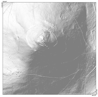 |
The Stallberg is located approximately 10 km northwest of the town of Hünfeld and 8 km west of the state line to Thuringia. It is part of the Hessian ‘skittles’ and, with 553 m asl, second highest peak in this range of hills. The dome-shaped summit slopes towards the east, featuring outcrops with basalt columns. Since 1973, the hilltop is part of a conservation area which, after 1997, has formed the core zone of the Rhön Mountains biosphere reserve. While prehistoric ramparts are present on the summit, several burial mounds are documented from the footslope. The plateau is surrounded by a 900 m long wall made of basalt stones enclosing an area of 6 ha. It has been paralleled with similar fortification systems in the region and was attributed to the Iron Age by researchers of the early 20th century. |
| Picture 1: DEM of Mount Stallberg with its fortification and burial mounds (bodenviewer.hessen.de - © GeoBasis-DE / BKG 2013, Hessische Verwaltung für Bodenmanagement und Geoinformation) |
| Prior to the excavation on the Stallberg, a number of surveys took place in May and July, 2016. On May 3rd, 2016, a first prospection with two metal detecting devices was carried out. However, only four sherds of indeterminate period were found, together with a few bullet casings probably originating from activities of the US Army during the Cold War. On May 31, 2016, a geophysical survey was conducted by M. Posselt of Posselt & Zickgraf Prospektionen GbR with the magnetometer on two small plots of 0.27 ha in total. Due to unfavourable geological conditions, i. e. strong magnetic anomalies caused by the basalt, no direct indication of archaeological structures could be located. However, the results show weaker magnetic zones in the natural soil or colluvial layers which may have been caused by archaeological material. On July 28, 2016, another survey with metal detectors took place. 159 objects have been gathered, recorded with GPS devices and referenced to Gauss Krüger coordinates. Summit, platforms and ramparts were surveyed. The finds which occurred at a higher density on the southwestern platform were all recovered from shallow depths of approximately 10 cm. They are mainly artefacts made of iron, such as a large number of nails, bullet cases, knife blades, horseshoes, several hooks as well as a few wedges. None of these finds could be dated to prehistoric times. | 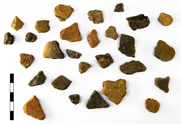 Picture 2: Ceramic sherds (Photo: B.Voss) Picture 2: Ceramic sherds (Photo: B.Voss) |
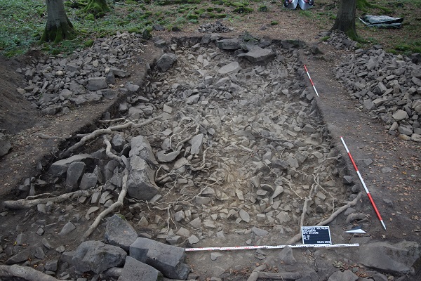 |
Between August 22 and September 30, 2016, an excavation took place on Mt. Stallberg in cooperation with Dr. F. Verse, head archaeologist for the town of Fulda, and the excavation company SPAU in Münzenberg. In the course of this campaign, 9 areas of approximately 117 m2 in total have been investigated. |
| Picture 3: Plot 1, Planum 2 (Photo H.Blitte) |
There was no direct evidence of prehistoric human activities. This is probably due to the thin soil cover on top of the intensely rugged phonolithic bedrock. Archaeological objects were mainly found on plot 1 on the western terrace. The other plots hardly contain any material, hence no soil samples were taken for archaeobotanical analysis. Most of the ceramic sherds found on the site are very small and damaged. Three well-preserved stone axes from plot 1, however, are considered to be particularly relevant. According to the method of N. Kegler-Graiewski, the axes can be associated with two different styles and periods. Two stone axes are trapezoidal and belong to type 2 from the Middle Neolithic (4400-3500 BC), most likely the Michelsberg culture. The third axe is rectangular (type 1) and believed to date back to the Final Neolithic (2800-2200 BC). The Neolithic occupation of the Stallberg is further underlined by the occurrence of several silex flakes and blade fragments as well as a small rim sherd probably from an “arcade-rim” ceramic. Some grinding stone fragments made of sandstone add to the picture but could not be assigned to a particular period.
The latest investigations and results from the Stallberg do not admit a dating of the rampart yet but point to a hitherto unknown occupation phase in the Middle Neolithic which attests the presence of the Michelsberg culture in the Hessian Rhön Mountains. A second excavation campaign is scheduled for Spring 2017 at the inside of the rampart in order to provide possible evidence on its age.
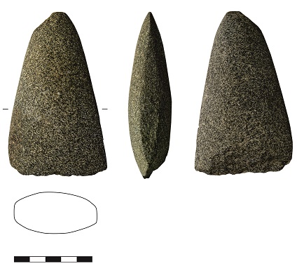 |
Picture 4: Stone axes (Photo: B.Voss) |
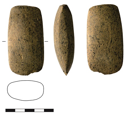 |
Picture 5: Stone axes (Photo: B.Voss) |
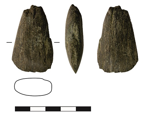 |
Picture 6: Stone axes (Photo: B.Voss) |
(Authoren: Hélène Blitte, Frank Verse, Rüdiger Krause)
Preliminary report in print for 2017:
H.Blitte, F.Verse, R.Krause, Der Stallberg bei Hünfeld – eine bronzezeitliche Höhenburg mit Befestigung? In: hessenARCHAEOLOGIE 2016